Mapping global
flood risk
One metre at a time

The same digital tools that protect global computer servers from flood damage promise to shed light on the social injustices of flooding under climate change.
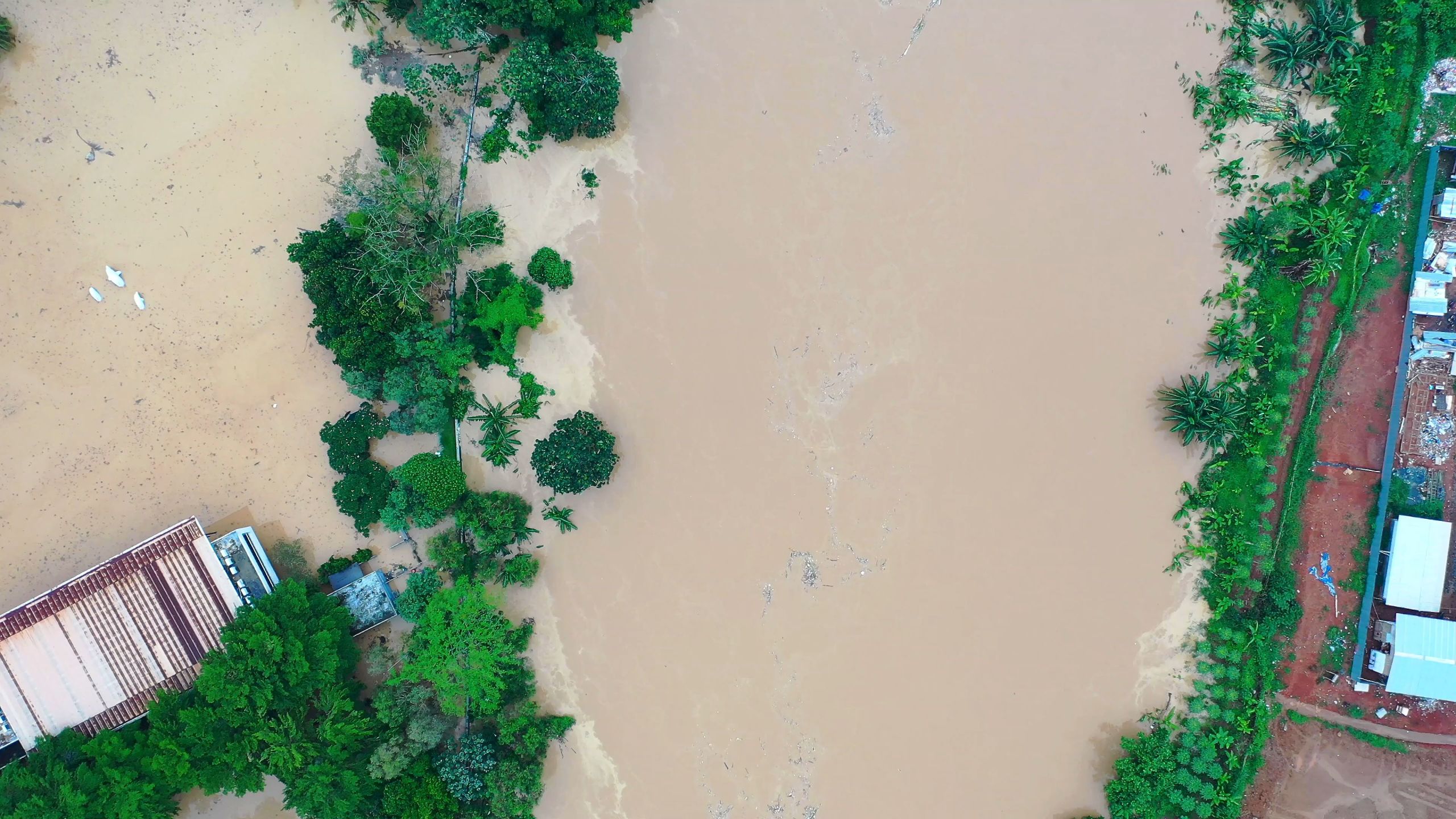
“Detail matters. Your house might flood but your neighbour’s—a metre or two higher—may not.” So explains Professor Paul Bates when describing the need for analytics that paint a hyper-local picture of flood risk.
“It’s hugely valuable to flood-management decisions if individual buildings, roads and detailed terrain form part of the picture that shape those choices,” Professor Bates continues.
“And this is true whether you’re an environmental protection agency seeking to better flood-proof a town, a humanitarian agency supporting communities after a natural disaster or an insurance company calculating potential flood-damage costs.”

Fine-tuned global analytics
Professor Bates and his colleague Dr Jeff Neal of the University of Bristol’s Hydrology research group are responsible for the world’s first high-resolution simulations of flooding, borne out of a research programme that began in 2008.
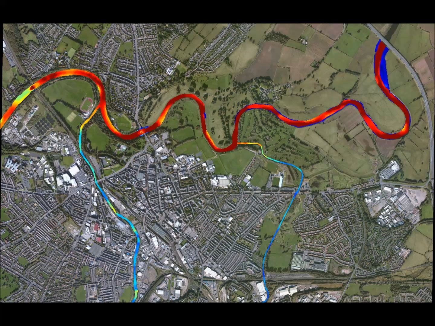
With these modelling tools, the team typically map flood risk at resolutions of 30–90 metres (i.e. a single 30-metre grid cell, for example, represents 30x30 (or 900) square metres of land).
With the right underpinning data and over a small area of land, these tools have also mapped flood risk in megacities at a one-metre resolution. In one UK case, mapping was done at just a 10-centimetre resolution.
It is not just the detail that is important, however. It is also the scale. Whilst many other models are able to simulate flood risk in high resolution at a local or regional level, Bristol’s flood-risk analytics can do so at the continental or global scale – and for any region of the world.
Previously, flood-risk analyses tended to focus on relatively small areas (river reaches a few tens of kilometres long) using detailed models and local data. They were also largely confined to the handful of developed countries with the resources to gather data using on-the-ground techniques, such as river and ground surveys. The earlier models that were capable of global and continental mapping tended to have resolutions of just one kilometre or more.


Professor Paul Bates
Professor Paul Bates

Dr Jeff Neal
Dr Jeff Neal
Underpinning both the high-level detail and vast scale of these modelling tools are a powerful set of algorithms developed by the research group.
These algorithms, which “essentially move water around a grid” allow for flood-risk assessments that are
10 to 100 times quicker than the methods
they replaced (Bates et al., 2010).

Powerful algorithms
“The beauty of our methods is that they are very computationally efficient. This means you can either use finer grids or cover bigger areas with the same amount of computing power,” explains Dr Jeff Neal, also of Bristol’s Hydrology research group.
“What we’ve achieved is not just about improvements to the quality or speed of flood-risk assessment though. We’ve also brought assessments within reach in the first place,” he continues.
“Greater computational efficiency lowers the financial cost of assessing floods because you have to buy fewer computers to do the same calculations. Some of the older methods were so much more expensive, often it wasn’t possible to even think about doing an assessment.”
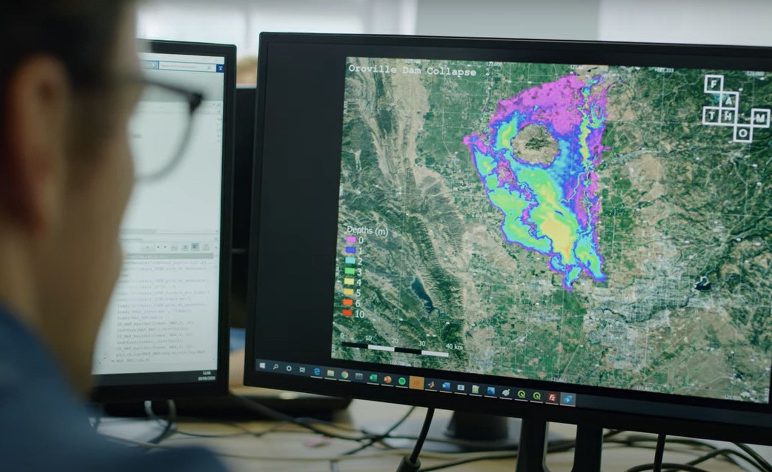
“We can now conduct a global assessment at 90-metre resolution in two-to-three months,” adds Professor Bates (see Sampson et al. (2015) for further details).
“So this remains a non-trivial operation, and we need to use a server with about 2,000 processors for the job. But it’s a world away from the 20-200 months it would have taken with older methods. Realistically, no-one is going to let you have a computer for that amount of time.”

Supporting communities, industry and NGOs
“If you can think of a sector, we try and work with them,” sums up Dr Neal when discussing the widespread need for their analytics.
Indeed, the need to understand flood risk has never been greater for quite so many sectors, and especially as we confront the tough realities – and uncertainties – of climate change.
To date, the Bristol team have lent their flood-risk expertise to online tech companies, insurance firms, supply chain managers, financial authorities, humanitarian response agencies, and many more.
“These organisations need large-scale and detailed views of flood hazard and risk to provide a clear picture of where exactly flooding could strike and what the resulting damage might be,” says Dr Neal. Often, this support is provided through the team’s spin-out firm, Fathom, set up in 2013 to make cutting-edge methods of flood-risk modelling more widely available.
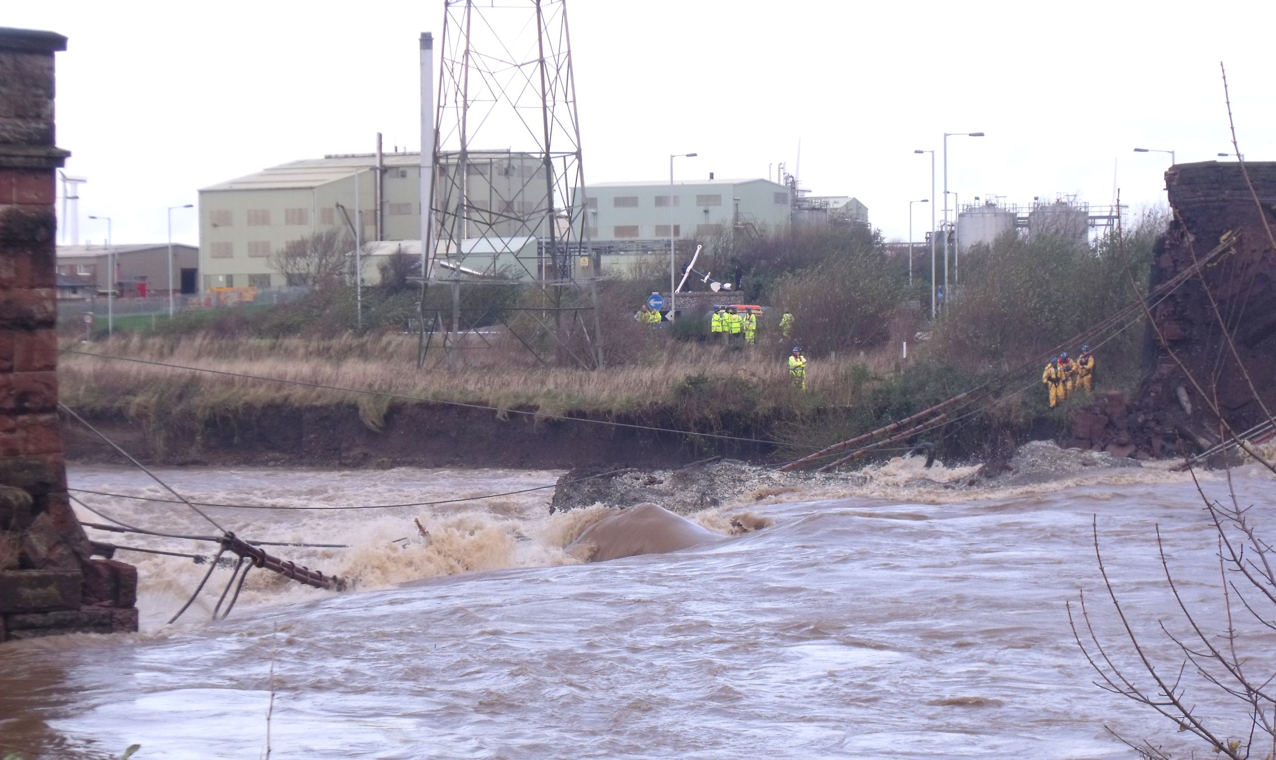
Notably, the research has helped humanitarian agencies prepare for disasters in a more targeted way. For instance, it has provided invaluable support for communities devastated by cyclones in eastern and southern Africa over recent years.
When Cyclones Idai and Eloise struck Mozambique in March 2019 and January 2021, for example, flood-risk maps compiled by the University of Bristol and partners helped UK Government-funded humanitarians predict which areas would be hit hardest and then plan supplies and staffing accordingly (see Emerton et al, 2020, for Cyclone Idai study).
Further, Bristol’s flood-risk intelligence has touched upon the daily lives of hundreds of millions of people around the world, although they’re unlikely to realise it. Through the spin-out Fathom, the team have supplied flood-risk data to Microsoft to assess risks to its global cloud infrastructure. This has helped Microsoft decide where to locate data centres, for instance, and how to optimise service delivery during extreme weather.
“If you’re using Microsoft Teams or OneDrive, or if you’ve got teenage kids on Xbox Live, all that is being routed through servers that are protected by our data.”
The World Bank also use the team’s data to assess national-scale flood risk in countries including Argentina, Belize, Bangladesh, Vietnam, Georgia and Armenia, and guide the Bank’s decisions on multi-billion USD investments and loans for infrastructure and disaster resilience projects.
In addition, the research has contributed to compelling economic arguments to protect wild areas, namely floodplains in the US. Working with the Nature Conservancy (TNC), one of the world’s largest environmental not-for-profit organisations, the Bristol researchers calculated that it makes far better financial sense to invest in floodplain protection now than to allow development on these natural areas of land – only to risk much costlier flooding in the future (Johnson et al., 2019).

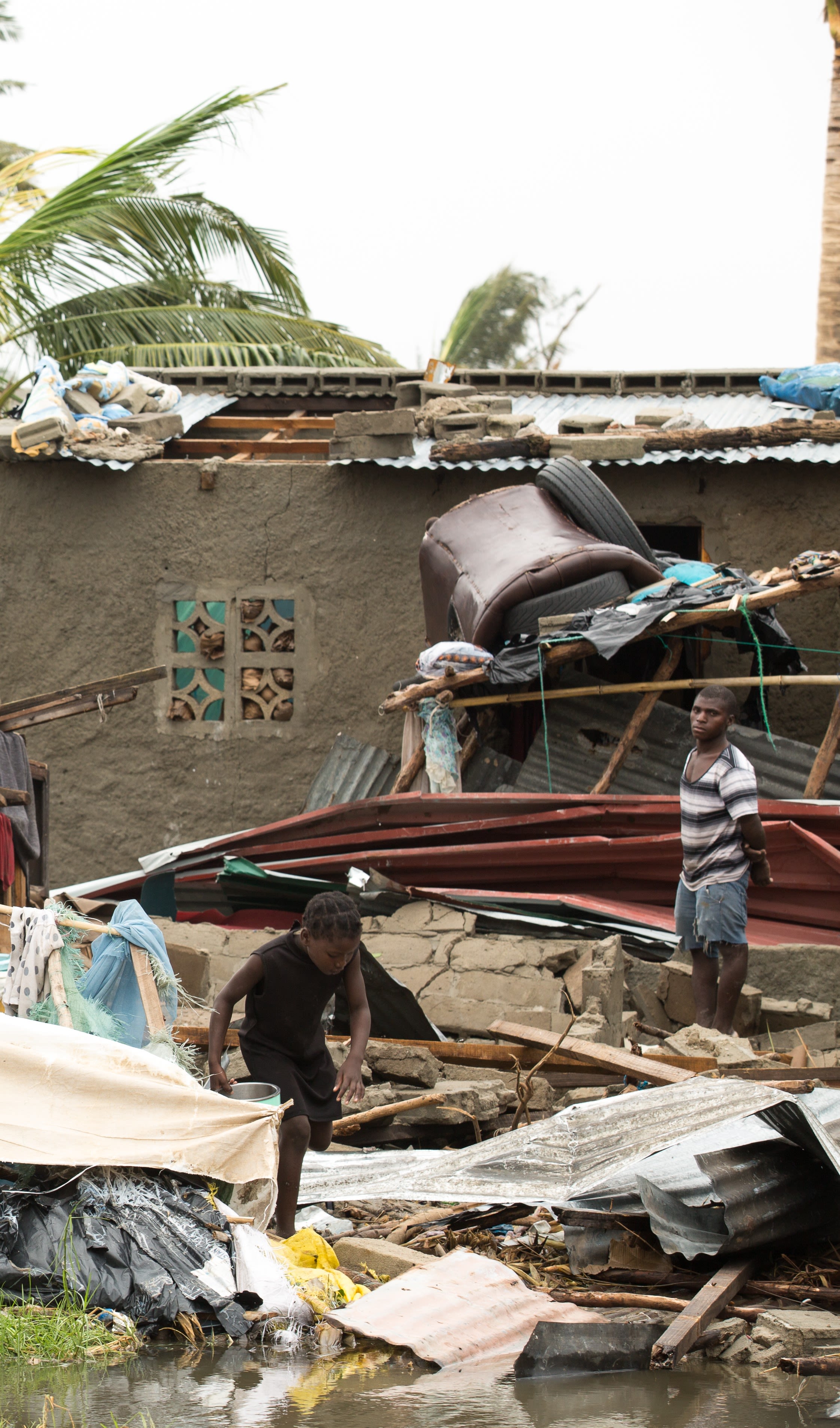
Cyclone damage, Mozambique (Image source: Climate Centre @Flickr CC BY-NC-SA 2.0)
Cyclone damage, Mozambique (Image source: Climate Centre @Flickr CC BY-NC-SA 2.0)
At the end of 2023, Swiss Re, one of the world's leading providers of reinsurance, announced it was acquiring Fathom.
“The mission remains the same; build the world’s best flood risk data,” Co-founder Dr. Andrew Smith said in an interview with SETsquared Bristol. “In our new home within Swiss Re we have the means to distribute what we have far more widely, so our models will get into many more people’s hands. We will also have the capabilities to accelerate and improve our products and roadmap. An exciting few years are ahead of us.”
For more information on the commercial licensing of flood models derived from the Group’s work:
“Is there a racial bias to flood risk?
Are poor people more at risk of flooding?”

Social justice and climate change
“Is there a racial bias to flood risk? Are poor people more at risk of flooding?” poses Professor Bates. These are questions that the Bristol research group are taking on in a new phase of their research.
Work by other scholars has provided examples from around the world of disproportionate impacts of flooding on more disadvantaged communities. This is for many reasons, including a lack of green space, such as parks and gardens, in inner-city areas to soak up excess rainfall, and a propensity by developers to build housing for poorer communities on floodplains, for example.
The Bristol group are further exploring the social distribution of flooding by fusing their flood-risk data with not just socio-economic data, but also future climate change projections.
“There is still quite some uncertainty when it comes to predicting the influence of climate change on flood risk,” Dr Neal explains. “Will flooding get worse or not? It will probably get worse in more places than it gets better, but it’s not a consistent signal everywhere.
“Through our work, we want to provide a clearer picture of just who is at risk of flooding, where, and how that might change in the future to help with social justice aspects of flood-risk policy.”
The research team’s work in this area so far has, for example, estimated a 30–127% increase in the number of people at risk from future floods in the US (Swain, et al, 2020), and emphasised the vulnerability of coastal communities in Bangladesh and India to sea-level rise and cyclones (Mitchell et al, 2020 (pre-print)).
Beyond academic papers
“University research in our field is often fixated on small scales. We’ve made a huge step to scale up our research through to a product that is really useful,” reflects Dr Neal on the impact of the research.
“We’ve gone well beyond writing an academic paper or method.”
Professor Bates adds: “The fundamental scientific advances we’ve made are really important— to push forward knowledge and change how people understand things is at the core of what we do as scientists,” before providing, perhaps, the final word on detail and scale: “However, the impact we’ve had on economic calculations and decisions that affect assets worth trillions of US dollars, and millions of people worldwide, is also what makes me very proud of our work.”


Tougher transport networks in the face of floods
How do we design cities to protect lives and prevent disruption from flooding? This question is at the heart of University of Bristol flood-management research which seeks to improve the resilience of urban transport networks and bridges.
Transport networks bind communities and support services together. A flooded road or collapsed bridge, for example, not only presents immediate threats to human safety, but has knock-on effects for the wider community.
“Flood damage can hinder access to hospital or delay the evacuation of a disaster-hit school, for example,” explains Dr Maria Pregnolato of Bristol’s Faculty of Engineering. “Furthermore, re-routing transport is very disruptive to local economies and communities.”
The key to urban resilience is to see the city as a system-of-systems, Dr Pregnolato believes, and to understand cascading consequences, that is, those knock-on effects of flooding (Arrighi et al., 2021).
This requires a truly multi-disciplinary approach, and her Engineering team are working with hydrologists, transport scientists, economists and urban scientists to understand vulnerabilities in transport networks and to compute losses.
The research is highlighting the need for both ‘grey’ (e.g. flood walls) and ‘green’ (e.g. rain gardens) measures in urban flood-risk management plans, as well as the importance of targeting limited resources for these at critical locations, given that flood-management investments typically have high benefit-cost thresholds (Pregnolato et al., 2016).


Dr Maria Pregnolato
Dr Maria Pregnolato

Northside Bridge, UK: scour caused its collapse in 2009, and the tragic death of a police officer. (Image source: Andy V Byers at English Wikipedia).
Northside Bridge, UK: scour caused its collapse in 2009, and the tragic death of a police officer. (Image source: Andy V Byers at English Wikipedia).
Further, Dr Pregnolato is exploring how to protect bridges from scour, the number one cause of bridge collapse worldwide. Scour occurs when sediment is washed away from around a bridge’s foundations and is exacerbated by high and/or turbulent river flows.
The research team will build upon initial analysis of scour-monitoring systems for bridges (Vardanega et al, 2021) to develop a comprehensive picture of the influences on scour risk, including changes in river systems and the way climate change affects bridges. Working with the UK’s rail network manager, Network Rail, and a consultancy firm, James Fisher Testing Services, Dr Pregnolato and colleagues are exploring how continuous monitoring technologies on rail bridges could allow for more targeted, efficient scour-mitigation measures.
Dr Pregnolato says, “Engineers in many countries think that numerous bridges could have already reached the end of their expected life spans. However, in the UK we do not know which bridges are most at risk of damage by flooding because there is no national database or method for identifying structures at risk at country-level.” (Pregnolato, 2019)
“We want our research to help identify those at-risk bridges. As well as protecting lives, this knowledge would have huge economic value given that all preventative actions taken before bridge failure are much less expensive than rebuilding or relocating bridges afterwards.”